Ryan120202 (talk | contribs) No edit summary Tag: Visual edit |
No edit summary |
||
| Line 1: | Line 1: | ||
{{incomplete}}{{See|For the ''[[Battlefield 2142]]'' map, see [[Verdun]]}} |
{{incomplete}}{{See|For the ''[[Battlefield 2142]]'' map, see [[Verdun]]}} |
||
| + | |||
{{Infobox/map |
{{Infobox/map |
||
|image = [[File:Verdun Heights Concept Art.jpg|270px]] |
|image = [[File:Verdun Heights Concept Art.jpg|270px]] |
||
| Line 78: | Line 79: | ||
|} |
|} |
||
| ⚫ | |||
| − | The village of Samogneux sits at the edge of the valley: |
||
| − | ====Samogneux North==== |
||
| ⚫ | |||
| + | ==Conquest== |
||
| ⚫ | |||
| ⚫ | |||
| − | === |
+ | ===Deployments=== |
| + | ====German Deployment==== |
||
| ⚫ | |||
| + | Located in the forest north of Samogneux Village. |
||
| + | |||
| + | ====French Deployment==== |
||
| + | The French deploy from the hill crest ''Côte'' 378 Battery. |
||
| + | |||
| + | ===Flags=== |
||
| ⚫ | |||
| + | The village of Samogneux sits at the edge of the valley. Samogneux is often approached from the west by German forces. One field has been tilled of hay—the bales providing some cover, but can be destroyed by explosives. Another field of bare trees forms the central approach. A hillside obscures vision into the valley leading to ''Côte'' 378. |
||
| + | |||
| ⚫ | |||
| + | A line of trenches to the north of Samogneux Village, blocking access to the valley beyond. |
||
| + | |||
| + | ====La Fontaine Ruins==== |
||
| + | The remains of a large church stand on a small hill, which itself conceals a large underground complex. |
||
===Mormont Trench=== |
===Mormont Trench=== |
||
| Line 97: | Line 109: | ||
An observatory is located halfway up the hillside opposite of ''Côte'' 378 and its defenses. This blockhouse uses a layout similar to those at ''Côte'' 378: Two entrances at either end leading underground, linked by a series of rooms, and interior staircases leading up to "cloche" observation posts that allow two occupants to look and fire outside. The cloche bell can be destroyed by explosives or artillery, turning the position into another point of access. |
An observatory is located halfway up the hillside opposite of ''Côte'' 378 and its defenses. This blockhouse uses a layout similar to those at ''Côte'' 378: Two entrances at either end leading underground, linked by a series of rooms, and interior staircases leading up to "cloche" observation posts that allow two occupants to look and fire outside. The cloche bell can be destroyed by explosives or artillery, turning the position into another point of access. |
||
| − | ===Côte 378 |
+ | ====Côte 378 Trench Lines==== |
| ⚫ | |||
| ⚫ | |||
| ⚫ | |||
| ⚫ | |||
| ⚫ | |||
| ⚫ | |||
| ⚫ | |||
| ⚫ | |||
| − | === |
+ | ===Sector 1=== |
| ⚫ | |||
| ⚫ | |||
| + | |||
| ⚫ | |||
| + | |||
| ⚫ | |||
| + | |||
| + | ===Sector 2=== |
||
| + | |||
| + | ===Sector 3=== |
||
| ⚫ | |||
| ⚫ | |||
| ⚫ | |||
==Frontlines== |
==Frontlines== |
||
| Line 119: | Line 136: | ||
German forces fall back to Samogneux. Objective A is in the central block, while Objective B is in one of the hillside houses. |
German forces fall back to Samogneux. Objective A is in the central block, while Objective B is in one of the hillside houses. |
||
| − | == |
+ | ===Flags=== |
| + | ====German Headquarters==== |
||
| ⚫ | |||
| + | German forces fall back to Samogneux. Objective A is in the central block, while Objective B is in one of the hillside houses. |
||
| + | ====Samoneux Villages==== |
||
| ⚫ | |||
| ⚫ | |||
| ⚫ | |||
| ⚫ | |||
| − | === |
+ | ====La Fontaine Ruins==== |
| + | Battle begins at La Fontaine Ruins. |
||
| − | === |
+ | ====Côte 378 Fortification==== |
| ⚫ | |||
| − | === |
+ | ====French Headquarters==== |
| + | French forces fall back to ''Côte'' 378 Trench Lines, with Objective A in the northeast corner of the battery, and Objective B behind the machine gun nest. |
||
| ⚫ | |||
==Rush== |
==Rush== |
||
| − | Rush on Verdun Heights takes place over five sectors, pushing through Samogneux up to the French defenses on ''Côte'' 378. |
+ | Rush on Verdun Heights takes place over five sectors, pushing through Samogneux up to the French defenses on ''Côte'' 378. As in Operations, the attackers recieve more tickets than the standard on other maps, amounting to 120 per wave instead of 75. |
===Sector 1=== |
===Sector 1=== |
||
| Line 159: | Line 176: | ||
A siege gun and elite kits are made available, this time for the French forces. While the German intruders may potentially take up the siege gun for themselves, the elite kits are kept in the French deployment. |
A siege gun and elite kits are made available, this time for the French forces. While the German intruders may potentially take up the siege gun for themselves, the elite kits are kept in the French deployment. |
||
| + | |||
| + | |||
| ⚫ | |||
| ⚫ | |||
| + | |||
| + | ===Mess Hall=== |
||
| ⚫ | |||
| + | |||
| ⚫ | |||
| ⚫ | |||
| + | |||
| ⚫ | |||
| ⚫ | |||
| + | |||
| + | |||
| + | ==Team Deathmatch== |
||
| + | |||
| + | |||
| + | ==War Pigeons== |
||
| + | |||
| + | |||
{{Maps/BF1}} |
{{Maps/BF1}} |
||
Revision as of 12:40, 2 April 2018
- This item has a Codex entry: Verdun Heights
— DLC Overview - Battlefield.com
Verdun Heights is a map featured in the Battlefield 1: They Shall Not Pass expansion. It takes place during the Battle of Verdun in the year 1916.
Overview
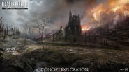
The major feature of Verdun Heights is the hillside in French territory, set ablaze by a recent artillery barrage. The French-controlled hills (côte in French) had been heavily fortified with trenches, bunkers, and machine gun positions, and overlooks the village of Samogneux at the bottom of the hill.
Verdun Heights is one of two maps that exclude mobile vehicles, the other being Fort De Vaux.
Behemoth
Instead of a Behemoth, four Elite Kits spawn for the losing side: one Flame Trooper kit, one Trench Raider kit and two Sentry kits, one wielding the Villar Perosa, the other wielding the MG 08/15. Along with the Elite Kits, each side will also receive access to the BL 9.2 Siege Gun, which can cover everything but beyond La Fontaine Ruin for either side. The Elite kits and siege guns are also used on Rush.
Control Points
| Control Point | Frontline | Conquest | Domination | Operations | Rush |
|---|---|---|---|---|---|
| German Deployment | |||||
| Samogneux North | 1A | Sector 1A | |||
| Samogneux Village | A | A | Sector 1B | ||
| Samogneux South | 1B | ||||
| Mormont Trench | B | Sector 2A | |||
| La Fontaine Ruin | B | C |
2A | Sector 2B | |
| Côte 344 Observatory | D | 2B | Sector 3 | ||
| Côte 378 Fortification | C | ||||
| Mess Hall | A | Sector 4B | |||
| Raynal Blockhouse | B | Sector 4A | |||
| Côte 378 Trench Lines | E | 3A | |||
| Côte 378 Battery | C | 3B | Sector 5 | ||
| French Deployment |
Conquest
Conquest on Verdun Heights takes an unusual S-shaped path through the map, with deployments tucked behind high ridges away from the main axis of battle. The map configuration allows the BL 9.2cm siege guns at each deployment to cover their respective half of the map.
Deployments
German Deployment
Located in the forest north of Samogneux Village.
French Deployment
The French deploy from the hill crest Côte 378 Battery.
Flags
Samogneux Village
The village of Samogneux sits at the edge of the valley. Samogneux is often approached from the west by German forces. One field has been tilled of hay—the bales providing some cover, but can be destroyed by explosives. Another field of bare trees forms the central approach. A hillside obscures vision into the valley leading to Côte 378.
Mormont Trench
A line of trenches to the north of Samogneux Village, blocking access to the valley beyond.
La Fontaine Ruins
The remains of a large church stand on a small hill, which itself conceals a large underground complex.
Mormont Trench
A line of trenches to the north of Samogneux Village, blocking access to the valley beyond.
La Fontaine Ruins
The remains of a large church stand on a small hill, which itself conceals a large underground complex.
Côte 344 Observatory
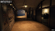
An observatory is located halfway up the hillside opposite of Côte 378 and its defenses. This blockhouse uses a layout similar to those at Côte 378: Two entrances at either end leading underground, linked by a series of rooms, and interior staircases leading up to "cloche" observation posts that allow two occupants to look and fire outside. The cloche bell can be destroyed by explosives or artillery, turning the position into another point of access.
Côte 378 Trench Lines
The Trench Lines are the next defensive line leading up to the battery.
Operations
Verdun Heights is the first map featured in Operation "Devil's Anvil". German battalions are made up of 350 tickets on this map instead of the usual 250.
Sector 1
Samogneux North is a larger cluster of residences and farm lofts located on the western side of the map. A pair of observation balloons are tied down on the southern side.
Samogneux is often approached from the west by German forces. One field has been tilled of hay—the bales providing some cover, but can be destroyed by explosives. Another field of bare trees forms the central approach. A hillside obscures vision into the valley leading to Côte 378.
Past a creek stand more buildings, and Samogneux South.
Sector 2
Sector 3
With Côte 378 cleared of defenders, the Germans advance on Fort De Vaux.
Frontlines
Battle begins at La Fontaine Ruins.
French forces fall back to Côte 378, with Objective A in the northeast corner of the battery, and Objective B behind the machine gun nest.
German forces fall back to Samogneux. Objective A is in the central block, while Objective B is in one of the hillside houses.
Flags
German Headquarters
German forces fall back to Samogneux. Objective A is in the central block, while Objective B is in one of the hillside houses.
Samoneux Villages
La Fontaine Ruins
Battle begins at La Fontaine Ruins.
Côte 378 Fortification
Two blockhouses at the foot of Côte 378.
French Headquarters
French forces fall back to Côte 378 Trench Lines, with Objective A in the northeast corner of the battery, and Objective B behind the machine gun nest.
Rush
Rush on Verdun Heights takes place over five sectors, pushing through Samogneux up to the French defenses on Côte 378. As in Operations, the attackers recieve more tickets than the standard on other maps, amounting to 120 per wave instead of 75.
Sector 1
The German Army starts in the southwest forest, and must clear Objective A in the first long farmhouse, and Objective B outside of the large central building.
The German BL 9.2 Siege Gun becomes available partway through battle, along with four elite kits (Trench Raider, two Sentries, and Flame Trooper).
Sector 2
French forces fall back to Mormont Trench and attempt to hold the church.
The German siege gun can still be used to attack Objective A, which sits on the western hillside. Objective B is found in the cellar under La Fontaine.
Sector 3
Battle resumes at Côte 344, with Objective A outside the observatory's southern entrance, and Objective B at its center.
Sector 4
With the threat of a rear assault cleared, the Germans advance up Côte 378. Objective A is inside the northern bunker, and Objective B is in the southern blockhouse's mess hall.
Sector 5
With the blockhouses overrun, the French set up their final defenses at the battery. Objective A is tucked behind the central machine gun nest, in front of the siege gun.
A siege gun and elite kits are made available, this time for the French forces. While the German intruders may potentially take up the siege gun for themselves, the elite kits are kept in the French deployment.
Domination
Combat takes place on Côte 378, between the blockhouses and the battery.
Mess Hall
Located in the southern of Côte 378's blockhouses. Kitchens in the eastern rooms serve the dining rooms in the west, and two cloches rise up to the valley side.
Raynal Blockhouse
The northern of the two blockhouses. Barracks quarters are available to either side of the hallway. A cloche can be accessed at the southwest corner, and an exterior hardened bunker stands to the south.
Côte 378 Battery
Site of the French Siege Gun.
Team Deathmatch
War Pigeons
| ||||||||||||||||||||
Gallery
Trivia
- In Samogneux, an easter egg can be triggered by finding and breaking a series of wine bottles concealed near the fence lines, then shooting at weather vanes on top of three buildings. Looking west, a house will then be seen carried aloft by three colored balloons. This is a reference to the movie Up, discovered by easter egg hunters on Discord.
- Raynal Blockhouse is likely dedicated to Sylvain Eugène Raynal, who as a major led the defense of Fort De Vaux, holding out for six days against forces led by Crown Prince Wilhelm of Prussia.
- Near the French deployment, a structural foundation forms the outline of a small-scale reproduction of Fort Douaumont.
- In the game files this map is named MP_Verdun.


